


As climate change increases the frequency and severity of flooding worldwide, the need for accurate monitoring tools has grown ever more pressing. NASA reports that the proportion of people living in flood-prone areas has jumped from 20 to 24 percent since 2000, endangering lives and property to an unprecedented degree. FloodNet is an open-source applied research project pioneering the use of real-time urban flood monitoring tools to manage weather events. It was developed in a collaboration between NYU Tandon researchers Charlie Mydlarz (Research Associate Professor at the Center for Urban Science and Progress) and Andrea Silverman (Associate Professor in the Department of Civil, Urban and Environmental Engineering) alongside CUNY research teams and New York City agencies.
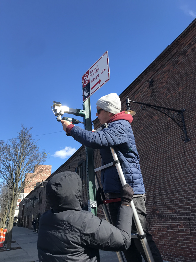
One of the largest flood-monitoring systems in the United States, FloodNet has deployed over 350 solar-powered sensors across New York City. “These are ultrasonic sensors that use inaudible sound waves to measure water depth,” Mydlarz explains. “They’re accurate to within an inch and they transmit data every minute to our central servers via cellular networks. We've built a whole back end that stores and processes the data while filtering false signals caused by objects like trash bags.” The processed information continually updates a publicly available data set and interactive maps on an online dashboard.
“One important use case is for emergency management agencies,” Mydlarz says. For example, the City has limited resources available for water rescues; the data show agencies how floods are developing and where, and assist in determining where the most acute needs for emergency response and post-flood recovery exist so they can allocate resources accordingly. Sensor data can identify points where drainage systems are not able to keep up with high intensity precipitation and, over time, may help predict problem locations. The data are also being used to help in the design of flood mitigation infrastructure, and will aid in evaluating the ability of that infrastructure to reduce stormwater floods in local neighborhoods. These use cases have all proven out as a robust return on New York’s $7.2 million in funding for sensor deployment in the city.
The team also affirms its open-source bona fides by making both the hardware designs and the real-time sensor data publicly available at dataviz.floodnet.nyc. “There are many use cases for the community too,” Mydlarz says. “Can I get to my subway stop? Do I need to move my car? Will my street be flooded? You can look at real time data and data from previous precipitation events and make better decisions.”
Building on community initiatives that began as early as 2018, the project took off in earnest in 2020, when NYU and CUNY teams that had been developing automated sensors independently began to combine their efforts. The results were so promising that the NYC Department of Environmental Protection provided the funding in 2022 for citywide rollout. The momentum helped spur team members to get involved in the NYU Leslie Entrepreneurial Institute pipeline, beginning with participation in the fall 2023 cohort of the NYU Tech Venture Workshop (TVW). “The aim of TVW for me was to learn about the various potential sectors we could approach with FloodNet,” Mydlarz recalls. “Being funded by the city, we had one data point of need in municipalities. I wanted to explore who else outside of city government had that need.”
The subsequent customer discovery interviews revealed a complicated landscape. “There was a fair amount of interest from the natural catastrophe insurance sector,” Mydlarz says. “There’s this whole world of parametric insurance, which automatically provides insurance payouts when triggered by sensor data and it was nascent at the time. But it was clear that the industry was only just then discussing the pivot.” Unusually, Mydlarz’s deep dive into the private sector reinforced the instinct to focus on the public sector. “It was really helpful through TVW to explore this network of private sector stakeholders and get outside, so to speak,” he explains. “There was not a resounding yes in terms of whether there was a market beyond the public sector but that in and of itself is certainly an answer.”
This refocused the direction their efforts took while participating in the NSF’s I-Corps program in the summer of 2025. “We doubled down on the public sector as a customer there,” Mydlarz says. “We conducted many more interviews and drilled down into various levels of stakeholders from public works agencies, to emergency response managers on different geographical scales and at city, county, state and federal levels.” The response this time was definitive. “We really confirmed the public sector need and discovered that it was most acute in emergency response,” Mydlarz recalls. “It taught us that in some regions emergency managers may be a first user of the data, since they’re the ones with the ‘hair on fire’ need as the Institute team puts it. Other agencies, like resilience agencies and public works agencies, may think in longer terms but could find value in the data as well.
Developing this strategy helped illuminate future growth paths. “We opened the doors to a number of potential customers,” Mydlarz says. “There were people who had heard of us thanks to the New York project and now want to deploy our devices. We have a few technological steps to clear first but, this year, we hope to have some serious conversations with people we met at I-Corps about considering pilots.” Mydlarz also credits the Institute team with helping surface these opportunities: “I see them as akin to a panel or a board that if you get even a half hour with, you leave with an incredible amount of leads or just different ways to think. Having that as a resource is invaluable.”
Meanwhile, FloodNet’s growth shows no sign of slowing. “This year, we will continue proving out our deployment in New York and hitting more advanced stages,” says Mydlarz. “We are looking to deliver on our goal of 500 sensors across the city by the end of 2026. We’re also aiming to secure more funding to support our R&D ambitions and public sector technology adoption/integration efforts for the next stretch.” And with the hoped-for deployments in new public sector initiatives, the commitment to communities in need is undimmed. “Our current focus is to deploy sensors and generate meaningful flood data in service of safer, more resilient communities.”


